
RESEPI Ultra LITE

Compact and light-weight, the RESEPI featuring the XT-32 LiDAR scanner is an all-around very attractive system, offering the benefits of best-in-class data accuracy, good detection range, high point density, and versatility.
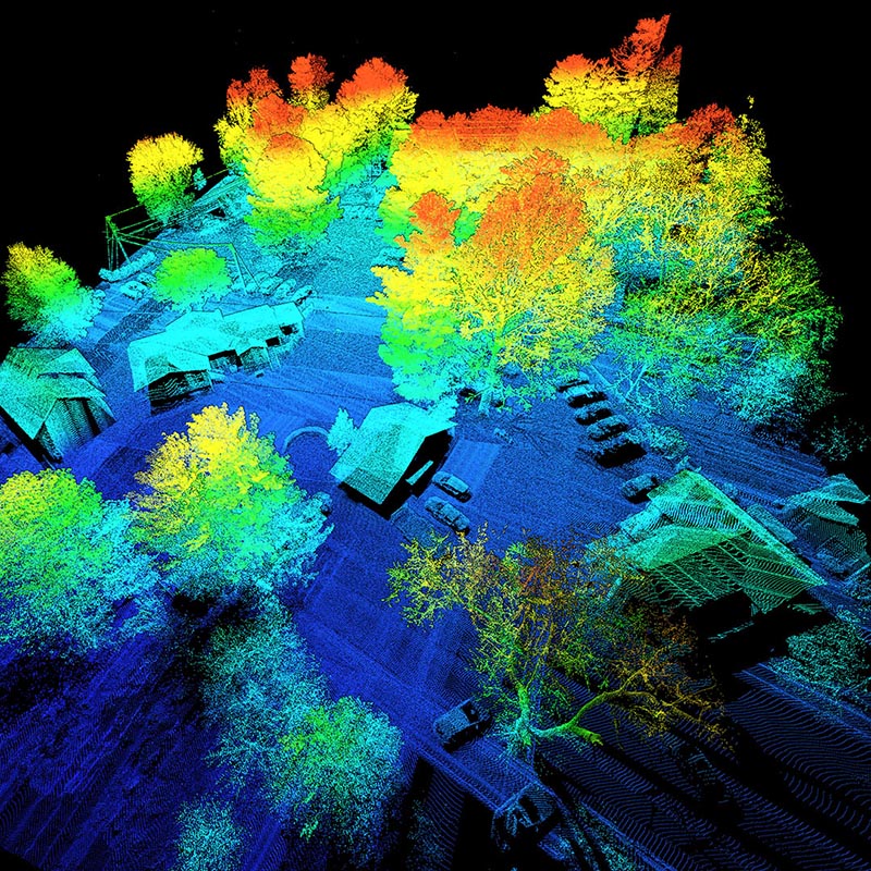
LiDAR
The XT-32 is uniquely one of the most competitively performing and priced LiDAR offerings on the market today. With a range precision of 0.5cm and an accuracy of ±1cm it does not disappoint when used on projects requiring a strict level of observable detail on surfaces. The XT-32 has also taken the time to improve upon other competitors weaknesses offering a zero-blind range feature which allows for point cloud data to be gathered and leveraged even at a range of essentially zero. Objects can be touching the sensor’s enclosure and they will still be registered as valid points! Don’t need this? No problem, clean it up with a single range filter in our software. Finally, reliability is also something to be confident in when using the XT-32 LiDAR. This LiDAR design has gone through international OEM testing standards that has covered and resulted in more than 50 successful reliability tests being completed and is designed for a lifetime usage of over 30,000 hours (typical).
Overview
Introducing the latest innovation from Inertial Labs, the lightest complete payload featuring both LiDAR and camera technology. Designed with the modern surveyor in mind, this solution offers unparalleled ease of use and versatility.
Key Features:
- Lightweight Design: Our lightest payload yet, ensuring ease of transport and deployment without compromising on performance.
- SnapFit Adapters: Experience seamless integration with various platforms (Freefly, WISPR, DJI, Sony, Mobile) through our quick plug-and-play SnapFit adapters, allowing for rapid dismounting and mounting.
- Cost-Effective: As the most affordable and comprehensive solution we’ve released, it provides exceptional value without sacrificing quality.
- Precision and Accuracy: High data accuracy and precision has remained our priority and promise to our customers. This product has gone through metiluous cycles of testing and refining in proper time-stamping and calibration methods to make sure we bring unrivaled performance at the right value.
- Multi-Mode Operations: Versatile in application, it supports aerial scanning, pedestrian hand-held SLAM operations, and vehicle-mounted mobile mapping, making it an all-in-one solution for diverse surveying needs.
This product embodies Inertial Labs’ commitment to innovation and excellence, providing surveyors and key-players in the 3D mapping space with a powerful tool that enhances efficiency and accuracy in their mapping projects.
Applications
The RESEPI Ultra LITE featuring the XT-32 LiDAR was strategically designed to accomodate the market needs for an all-in-one system that delivers accuracy and precision to 3D mapping applications. The RESEPI Ultra LITE has SnapFit adapters designed and released specifically to support common Freefly, WISPR, and DJI drones. This payload with it’s embedded 5MP colorization camera and ultra-lightweight design is going to achieve maximum return for endurance missions in aerial mapping and low to mid-range altitudes. Given the compact nature of the system it is also perfect for SUAS integrators to adopt and bring inside to any platform with volume constraints where both LiDAR and a camera are the desired configuration. This RESEPI system will see its highest return on investment where customers are conscious of cost but still desiring to see a quality point cloud primarily in the applications of: utilities mapping (power lines), construction volumetrics, site surveying, precision agriculture, forestry, mining operations, and much more.
System Specification
cm
System Vertical Accuracy
cm
Precision
cm
Precision
(1σ Noise Removal)
meters
Recommended AGL
kg
Weight
cm
Dimensions
minutes
Max Flight Time (DJI M350)
GB
External Storage, USB
1GB RAM, 8GB eMMC
System Computer
Volt
Operational Voltage Range
Watt
Power Consumption
LiDAR Scanner
| Laser Range Capabilities |
80m @ 10% ref. (c9-24) 50m @ 10% ref. (c1-8, 25-32) 0.05 to 120m |
| Range Accuracy | +/- 1 cm |
| FOV (Horizontal) | 360° |
| FOV (Vertical) | 31° |
| Scan Angle (Vertical) | -16° to 15° |
| Beam Divergence | 0.021° (H), 0.047° (V) |
| Laser Channels | 32 |
| Number of Returns | 2 |
| Pulse Rate |
640k/s (single return) 1,280k/s (dual return) |
Camera
| Model | CMOS Rolling Shutter |
| Resolution | 5MP |
| Lens | Fixed, Manual Focus |
| Max Trigger Rate | 2 seconds |
| Field of View | HFOV = 70.8°, VFOV = 55.6° |
GPS-Aided INS
| IMU | Inertial Labs KERNEL-210 |
| GNSS | NovAtel OEM7500 |
| Constellations | GPS, GLONASS, Galileo, BeiDou, QZSS, SBAS, L-Band |
| Frequencies | L1, L1C, L2, L2C, B1, B2, E1, E5b |
| Operation Modes | RTK and PPK |
| INS Algorithm Type | Extended Kalman Filter |
| Output Rates |
Up to 200HZ (INS) Up to 2,000HZ (IMU) |
| Pitch/Roll Accuracy |
0.03° (RTK) 0.004° (PPK) |
| Heading Accuracy |
0.1° (RTK) 0.02° (PPK) |
| Velocity Accuracy | <0.03 m/s |
| Position Accuracy |
1cm + 1ppm (RTK) 0.5cm (PPK) |
Software (PCMasterPro)
| Field Checks | Yes |
| Pre-Processing | Yes |
| Post-Processing | Yes, Supported |
| SLAM (Powered by Kudan) | Yes |
| Strip Alignment (Powered by BayesMap) | Yes |
| Additional Features | Coordinate System Transformation, Batch Processing, Open Architecture, Noise Filtering, etc. |