

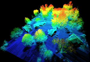
A LiDAR remote sensing payload instrument is a device that uses light to measure distances from a sensor to objects in the real world. It does this by emitting a laser beam and measuring the time it takes for the beam to travel to the object and back. This information is then used to create a 3D point cloud of the object or scene.
LiDAR remote sensing payload instruments are used in a wide variety of applications, including:
- Mapping and surveying: LiDAR can create detailed maps of the Earth’s surface, including topography, vegetation, and infrastructure. This information can be used for various purposes, such as planning construction projects, managing natural resources, and responding to natural disasters.
- 3D modeling: LiDAR can create 3D models of objects and scenes. This information can be used for a variety of purposes, such as creating virtual worlds for gaming and entertainment or engineering and design purposes.
- Remote sensing: LiDAR can collect data from remote locations, such as forests, oceans, and glaciers. This information can be used to study the environment, monitor changes over time, and identify potential hazards.
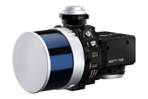
The Inertial Labs RESEPI
The Inertial Labs RESEPI is a LiDAR remote sensing payload instrument designed for use in various applications. It is a compact, lightweight system that can easily be mounted on a drone, aircraft, or ground vehicle.
The RESEPI includes several features that make it a powerful tool for remote sensing, including:
- High-accuracy GNSS-aided inertial navigation system: The RESEPI’s GNSS-aided inertial navigation system (INS) provides high-accuracy position and orientation data, even in GPS-denied environments. This data is used to ensure that the LiDAR data is accurately georeferenced.
- High-resolution LiDAR scanner: The RESEPI’s LiDAR scanner can generate up to 1 million points per second, providing high-resolution 3D data.
- Integrated camera: The RESEPI includes an integrated camera that captures high-resolution images of the scanned scene. This imagery can be used to help align the LiDAR data and the camera data and can also be used for other purposes, such as creating orthophotos or virtual tours.
- Data processing software: The RESEPI includes data processing software that can process LiDAR data and create 3D point clouds, 3D models, and other outputs.
The RESEPI is a powerful tool that can be used for various remote sensing applications. It is a compact, lightweight, easy-to-use system that provides high-accuracy data.
Benefits of using LiDAR remote sensing payload instruments
There are many benefits to using LiDAR remote sensing payload instruments, including:
- Accuracy: LiDAR data is highly accurate, precisely measuring distance and location. This accuracy is essential for many applications, such as mapping and surveying, where even minor errors can significantly impact the results.
- Resolution: LiDAR data can be collected at high resolutions, providing a detailed 3D view of the environment. This high resolution is ideal for applications such as 3D modeling and remote sensing, where it is vital to see small details.
- Speed: LiDAR data can be collected quickly, making it a cost-effective option for large-scale projects.
- Versatility: LiDAR can be used in various environments, including forests, oceans, and glaciers. This versatility makes it a valuable tool for a wide range of applications.
Applications of LiDAR remote sensing payload instruments
LiDAR remote sensing payload instruments are used in a wide variety of applications, including:
- Mapping and surveying: LiDAR can create detailed maps of the Earth’s surface, including topography, vegetation, and infrastructure. This information can be used for various purposes, such as planning construction projects, managing natural resources, and responding to natural disasters.
- 3D modeling: LiDAR can create 3D models of objects and scenes. This information can be used for various purposes, such as creating virtual worlds for gaming and entertainment or engineering and design.
- Remote sensing: LiDAR can collect data from remote locations, such as forests, oceans, and glaciers. This information can be used to study the environment, monitor changes over time, and identify potential hazards.
Future of LiDAR remote sensing payload instruments
The use of LiDAR remote sensing payload instruments is expected to grow. This growth is being driven by several factors, including:
- The increasing availability of LiDAR data
- The decreasing cost of LiDAR data
- The increasing demand for high-accuracy, high-resolution data
- The growing need for 3D data
As the use of LiDAR remote sensing payload instruments grows, we can expect to see new and innovative applications for this technology.
LiDAR remote sensing payload instruments are powerful tools that can be used for various applications. The Inertial Labs RESEPI is a high-quality system that is designed for use in a variety of environments. It is a compact, lightweight, easy-to-use system that provides high-accuracy data.